At 6.20 a.m:
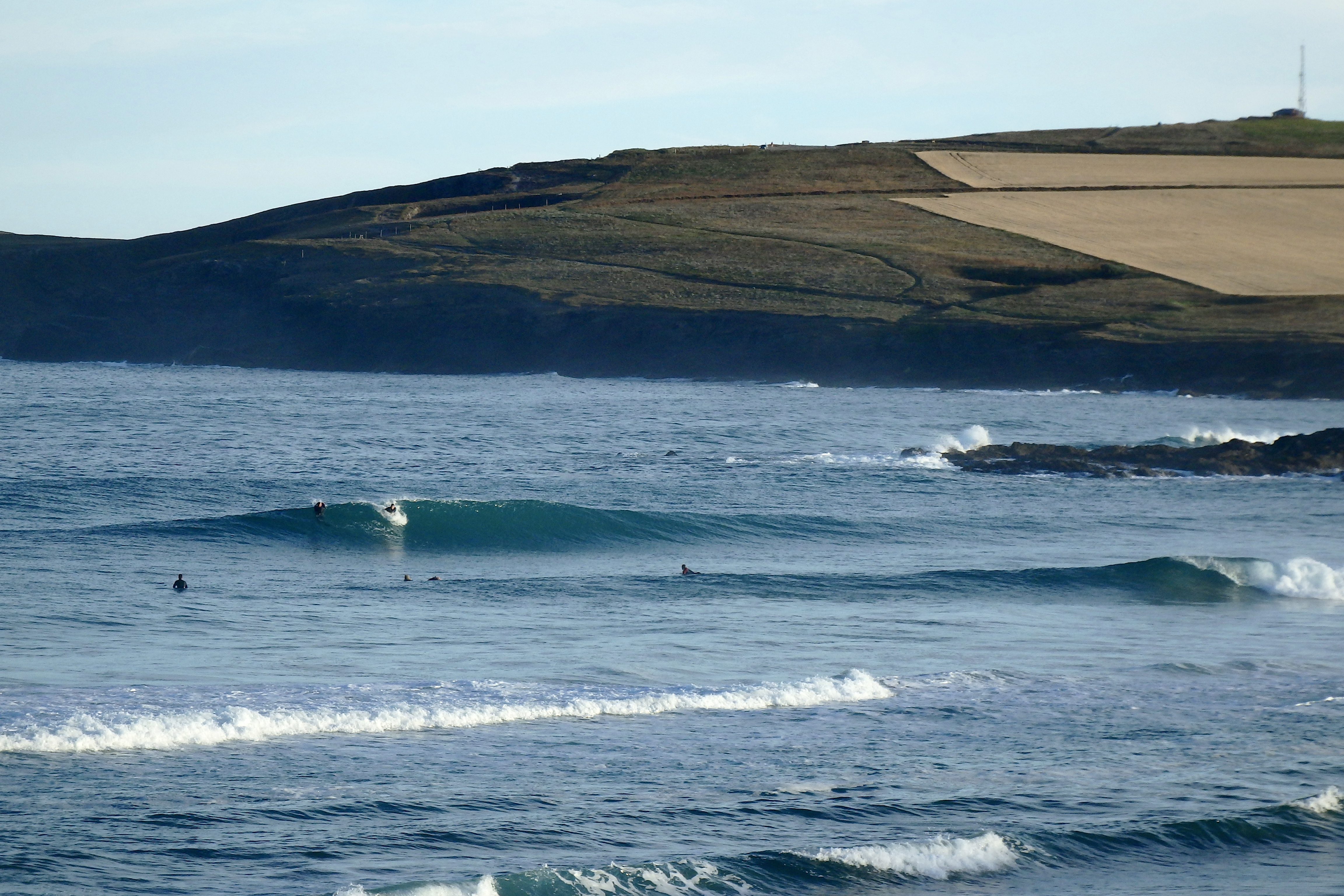
Constantine (4*): 3 feet.
A wide open and deep blue sky is greeting us this morning, slivers of light cloud adding to the clarity of a wonderful summer’s morning.
The air is still, the sky is clear, the birds are chortling in tune and the surf is beautiful!
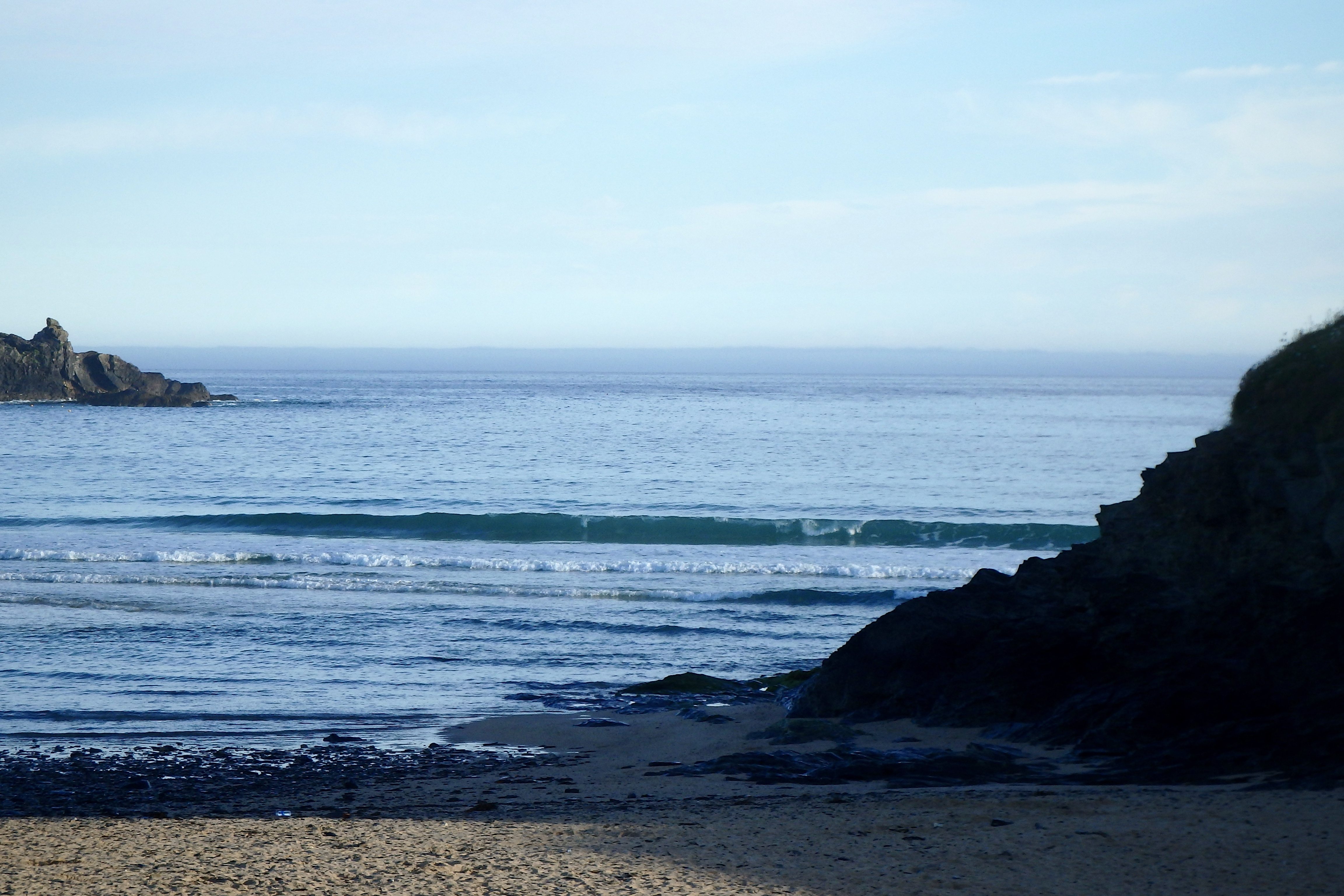
Three feet of crystal clear and oilly smooth waves are spilling into the bay, peaking and reeling to the beach.
Toby D is on an early morning birthday blast, flashing a self shaped tiny orange wave slasher across those deep blue waves and the paler blue sky. The boy is ripping!!
And the rest of the day looks settled and fine, the temperatures set to relax in the mid 20s celsius, with mainly clear skies and light offshore breezes.
Enjoy!
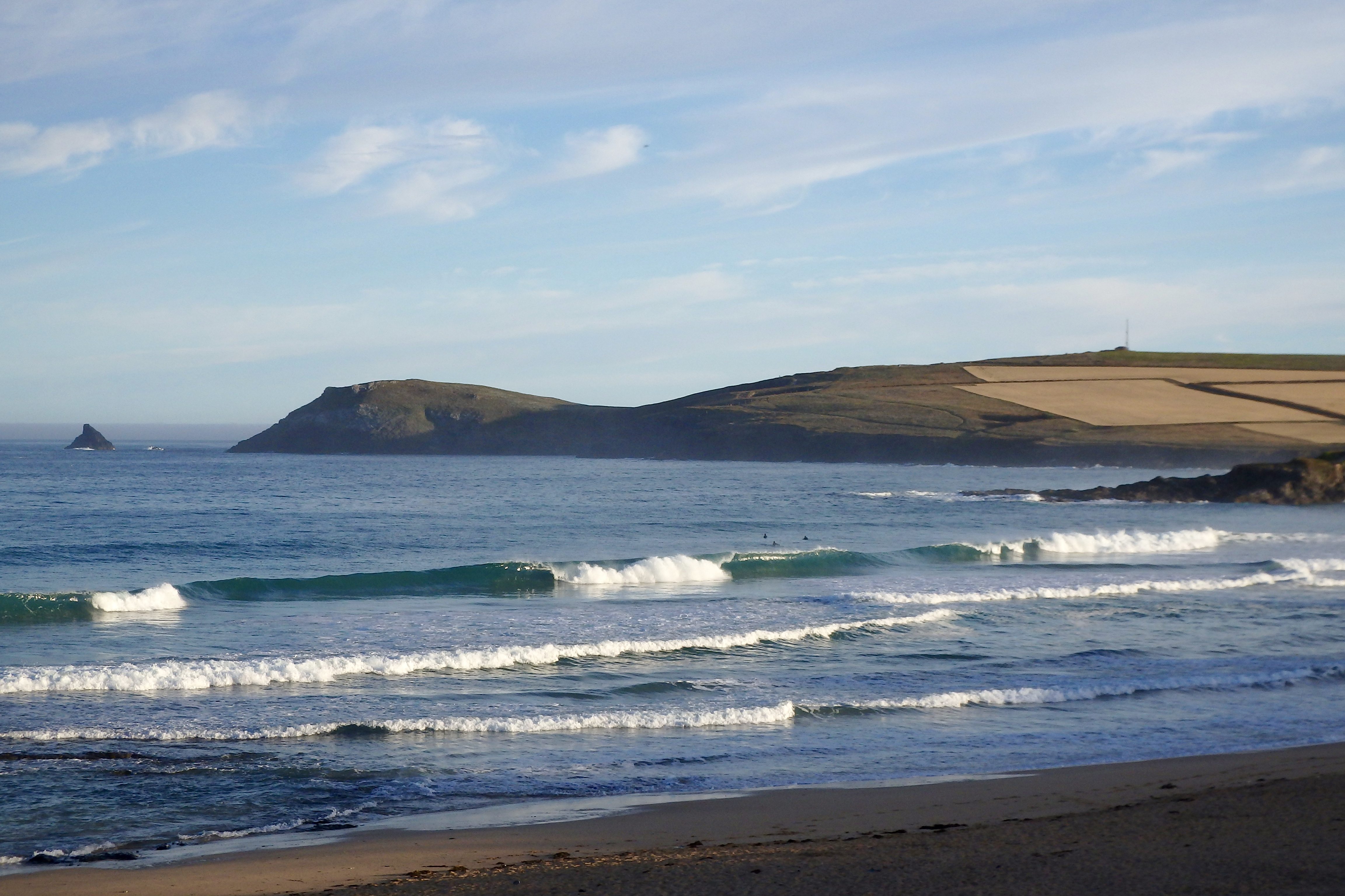
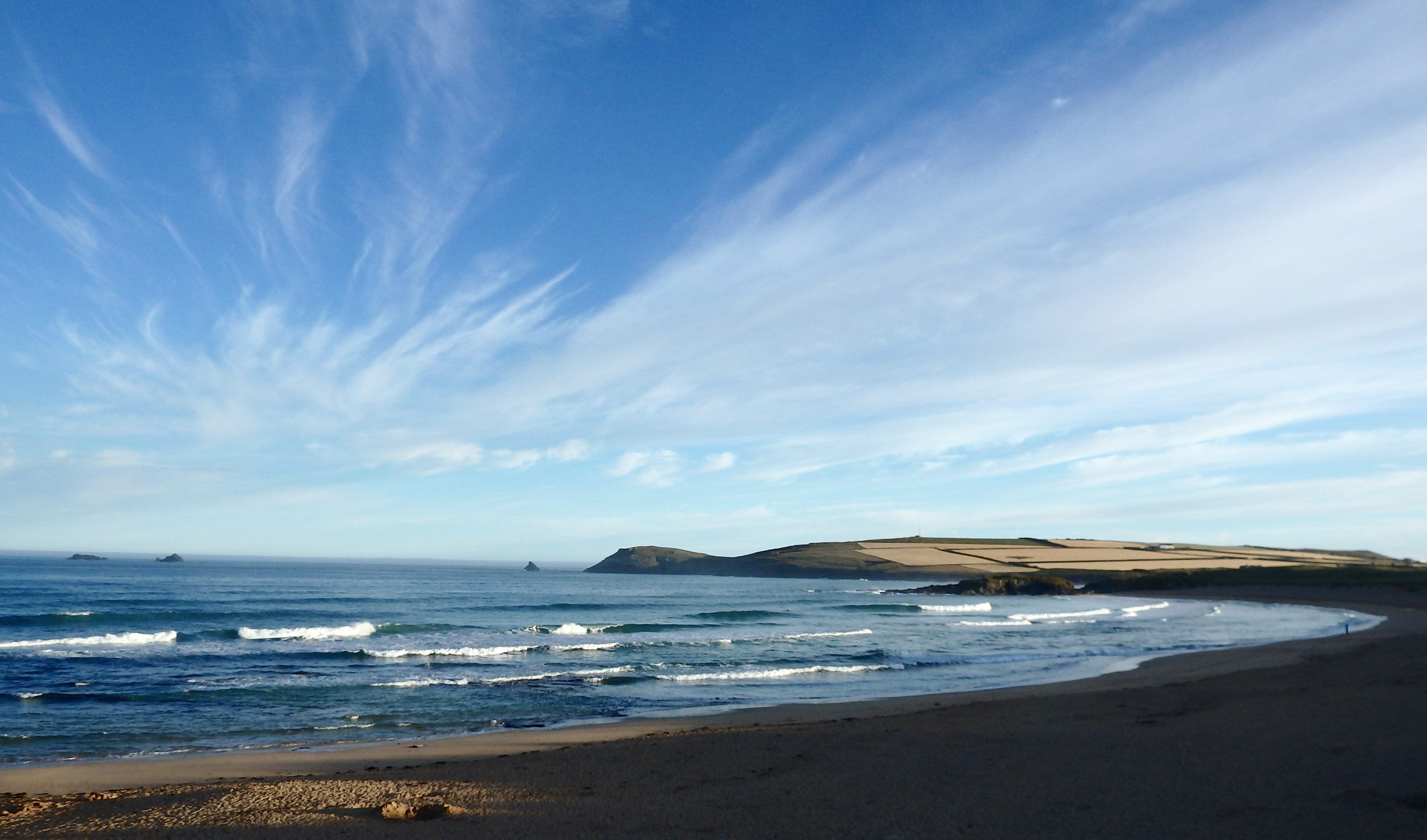
Harlyn (1*): 1 foot
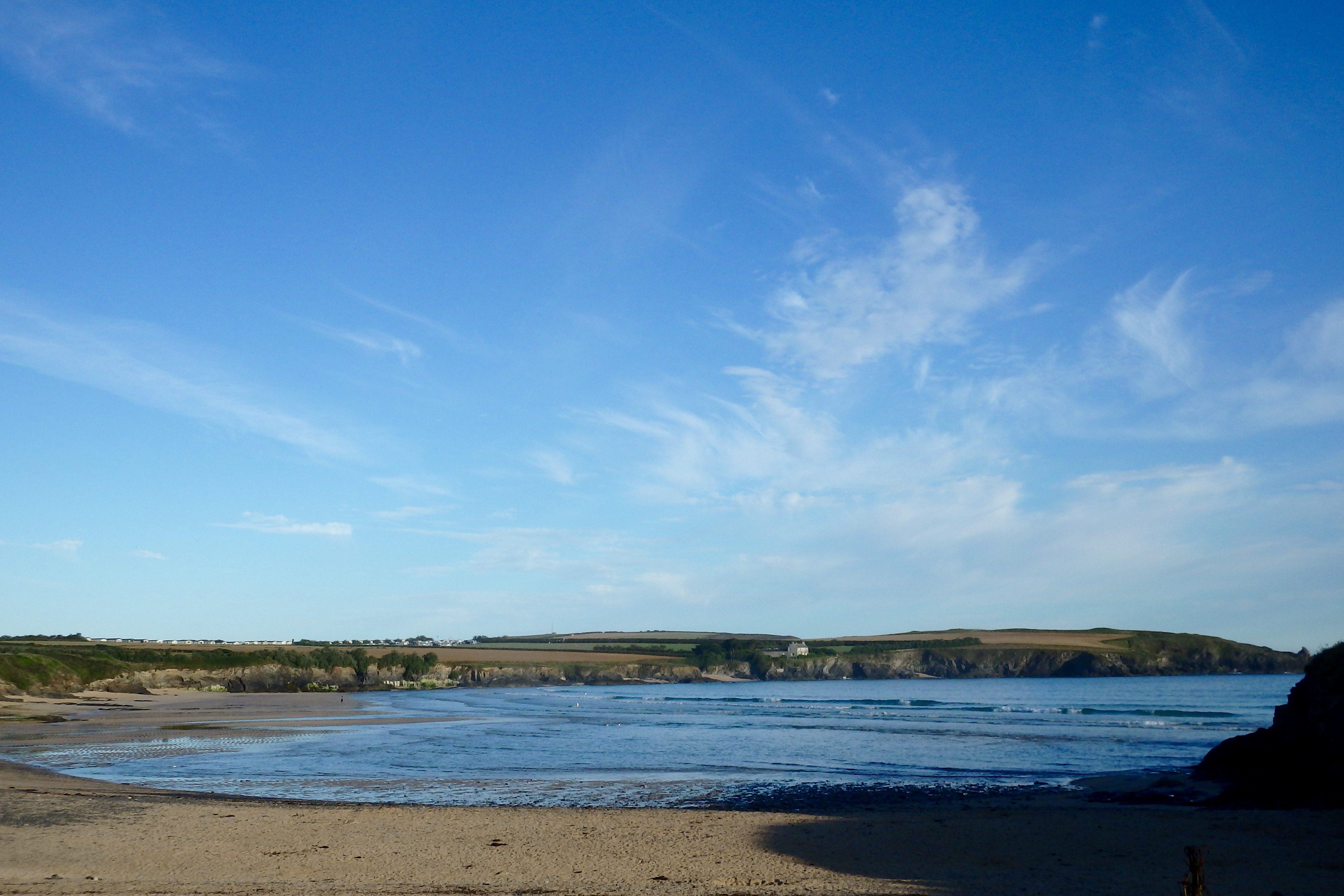
There are small and glassy, one to two foot little waves trickling into Harlyn this morning, those oilly glass waves spilling onto the golden yellow sand in groups of four or five.
The tide is on the drop and so you can see the pull against those weak looking little waves.
It is likely to improve as the afternoon tide pulls back in but it is probably going to be pretty tiny still. And with the other side cooking along, then you’re probably going to be better off going there for a surf.
But it is gorgeous, as usual, here this morning!
Today’s Tide Times:
Low Tide: 11:31 (1.7m) High Tide: 17:25 (6.8m)

Surf Forecast for Tuesday 19th July 2016
Small but pretty, offshore shaped little peelers should continue to keep us entertained today, the temperatures set to stay high and the skies staying mainly clear and bright.
Settled summer conditions have established themselves this week and today could just be one of those days of pleasantly warm weather and beautifully shaped, if a little small surf.
Have a great day!
Surf Conditions for the Start of the Week
Smooth and clean conditions are expected to start this week’s surf conditions, the breeze set from the south east for a day or two while a small but steady little swell continues to peel our way.
The longboarders should be having a glide through Monday and Tuesday as a foot or two of peeling little swells shimmy into the bays and coves all along the coast. It’s a shame that there won’t be anything bigger but then, it is Summer and so we’ll have to accept what we can find!
By midweek the breeze will have settled back to the west, onshore but hopefully only very lightly onshore. And that should at least support those little swells and keep them rolling our way.
So, a summery week awaits, full of promise for some clean and fun, bright and sunny surfing!
Have a great week, wherever you are and whatever you’re doing!
SJ’s Surf Forecast for the SW
Forecast last updated at 09:00 Monday 18th July 2016
Hi everyone – these updates are currently made at any time of the day as and when I get the time/chance to update – however from September the intention would be for it to be updated every weekday morning by 10am.
[Don’t forget to look at this forecast the day before you go beach for the latest, as things can often change!]
The Rest Of The Week:
‘Fantastic start to the week – make the most of this classic Summer spell before conditions deteriorate!’
Sunrise and sunset – 05:35 and 21:20
Twilight starts and ends – 04:55 and 22:00
Midday – 13:25
Length of day – 15:45
Offshore Sea Temp approx – 16.5C / 62F
outputmodelrun-180716-0900
Monday 18th:
‘Stunning day. Surf will be going off. Get on it!’
Swell – (i) OK W going Weak W-WNW
Wind – Light-Medium ESE-SE
Weather – Hot summery blue sky day.
North Coast – 3ft (Waisthigh) going 2-3ft (Knee-Waisthigh)
South Coast – 1ft
Tides – 11:13 Low, 17:09 High
Tuesday 19th:
‘Smaller than Monday, but with offshores and sunny weather – it’ll still be a great day.’
Swell – (i) Weak going OK W-WNW
Wind – Medium ESE-SE going Light-Medium SE
Weather – Hot Summery blue sky day. Clouding over later on with a chance of thunder.
North Coast – 1-2ft (Kneehigh) going 2-3ft (Knee-Waisthigh)
South Coast – 1-2ft (Kneehigh) going 1ft
Tides – 05:29 High, 11:51 Low, 17:48 High
Wednesday 20th:
‘A return to onshore conditions for the North with WNW winds and cloudier skies.’
Swell – (i) OK W-WNW
Wind – Medium WNW
Weather – Chance of thunder/rain first thing, then a mixture of cloud and sunshine.
North Coast – 2-4ft (Waisthigh) going 3-5ft (Waist-Shoulderhigh)
South Coast – 1-2ft (Kneehigh)
Tides – 06:08 High, 12:29 Low, 18:27 High
Thursday 21st:
‘There’ll be waves aplenty on the North,but they’ll lack any real qulity with the SW winds.’
Swell – (i) OK W-WNW going Weak W
Wind – Light-Medium WSW-SW
Weather – Mixture of cloud, sunshine, and showers.
North Coast – 3-4ft (Waist-Chesthigh) going 3ft (Waisthigh)
South Coast – 1-2ft (Kneehigh)
Tides – 06:47 High, 13:07 Low, 19:07 High
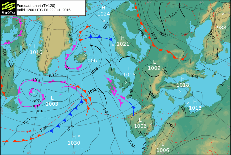
Friday 22nd:
‘A clean wave on the North first thing around the high/dropping tide at semi sheltered spots. Winds will turn onshore NW later on though.’
Swell – (i) Weak W-WSW
Wind – Light-Medium S going NW
Weather – Mixture of cloud, sunshine, and showers.
North Coast – 3ft (Waisthigh)
South Coast – 1ft
Tides – 07:28 High, 13:49 Low, 19:48 High
Weekend Summary:
‘Poor quality waves with a weak swell and onshore conditions, but at least it won’t be flat.’
Saturday 23rd:
‘Onshore sloppy surf.’
Swell – (i) Weak W
Wind – Light-Medium NW going WSW
Weather – Cloudy but dry.
North Coast – 3ft (Waisthigh)
South Coast – 1ft
Tides – 08:09 High, 14:31 Low, 20:31 High
Sunday 24th:
‘SW winds and a weak swell will mean not much quality to the surf, but at least it won’t be flat.’
Swell – (i) Weak W
Wind – Medium W-SW
Weather – Mixture of cloud, sunshine, and showers.
North Coast – 3-4ft (Waist-Chesthigh)
South Coast – 1-2ft (Kneehigh)
Tides – 08:52 High, 15:14 Low, 21:15 High
Early Next Week:
‘Too early to tell yet.’
The scale for measuring conditions:
0-1ft – Unridable/Flat
1-2ft – Kneehigh
3ft – Waisthigh
4-5ft – Chest/Shoulderhigh
6ft – Headhigh
6-8ft = 1-1.5x Overhead
8-10ft = 1.5x Overhead
10-12ft = 2x Overhead
Please Note!
Wave height predictions are based on the larger breaks on both coasts such as Fistral and Croyde for the North, and Praa Sands and Bantham for the South.
Wave height is measured from the front of the wave, and 6ft would usually mean a ‘head-high’ wave.
Try and use some ‘local’ knowledge about what the wave sizes will be elsewhere. For example the Newquay Bay area is generally 1/3 to 3/4 the size of Fistral, increasing the further up the bay you go from Towan to Lusty Glaze, and that it will be clean on a W wind at ‘harbour left’ at Towan at mid-tide’ for example.
Tide times are based on Newquay.
Stay Stoked!
SJ
(reposting…)
SJ’s Surf Forecast for the SW
Forecast last updated at 09:00 Monday 18th July 2016
Hi everyone – these updates are currently made at any time of the day as and when I get the time/chance to update – however from September the intention would be for it to be updated every weekday morning by 10am.
[Don’t forget to look at this forecast the day before you go beach for the latest, as things can often change!]
The Rest Of The Week:
‘Fantastic start to the week – make the most of this classic Summer spell before conditions deteriorate!’
Sunrise and sunset – 05:35 and 21:20
Twilight starts and ends – 04:55 and 22:00
Midday – 13:25
Length of day – 15:45
Offshore Sea Temp approx – 16.5C / 62F
outputmodelrun-180716-0900
Monday 18th:
‘Stunning day. Surf will be going off. Get on it!’
Swell – (i) OK W going Weak W-WNW
Wind – Light-Medium ESE-SE
Weather – Hot summery blue sky day.
North Coast – 3ft (Waisthigh) going 2-3ft (Knee-Waisthigh)
South Coast – 1ft
Tides – 11:13 Low, 17:09 High
Tuesday 19th:
‘Smaller than Monday, but with offshores and sunny weather – it’ll still be a great day.’
Swell – (i) Weak going OK W-WNW
Wind – Medium ESE-SE going Light-Medium SE
Weather – Hot Summery blue sky day. Clouding over later on with a chance of thunder.
North Coast – 1-2ft (Kneehigh) going 2-3ft (Knee-Waisthigh)
South Coast – 1-2ft (Kneehigh) going 1ft
Tides – 05:29 High, 11:51 Low, 17:48 High
Wednesday 20th:
‘A return to onshore conditions for the North with WNW winds and cloudier skies.’
Swell – (i) OK W-WNW
Wind – Medium WNW
Weather – Chance of thunder/rain first thing, then a mixture of cloud and sunshine.
North Coast – 2-4ft (Waisthigh) going 3-5ft (Waist-Shoulderhigh)
South Coast – 1-2ft (Kneehigh)
Tides – 06:08 High, 12:29 Low, 18:27 High
Thursday 21st:
‘There’ll be waves aplenty on the North,but they’ll lack any real qulity with the SW winds.’
Swell – (i) OK W-WNW going Weak W
Wind – Light-Medium WSW-SW
Weather – Mixture of cloud, sunshine, and showers.
North Coast – 3-4ft (Waist-Chesthigh) going 3ft (Waisthigh)
South Coast – 1-2ft (Kneehigh)
Tides – 06:47 High, 13:07 Low, 19:07 High
Friday 22nd:
‘A clean wave on the North first thing around the high/dropping tide at semi sheltered spots. Winds will turn onshore NW later on though.’
Swell – (i) Weak W-WSW
Wind – Light-Medium S going NW
Weather – Mixture of cloud, sunshine, and showers.
North Coast – 3ft (Waisthigh)
South Coast – 1ft
Tides – 07:28 High, 13:49 Low, 19:48 High
Weekend Summary:
‘Poor quality waves with a weak swell and onshore conditions, but at least it won’t be flat.’
Saturday 23rd:
‘Onshore sloppy surf.’
Swell – (i) Weak W
Wind – Light-Medium NW going WSW
Weather – Cloudy but dry.
North Coast – 3ft (Waisthigh)
South Coast – 1ft
Tides – 08:09 High, 14:31 Low, 20:31 High
Sunday 24th:
‘SW winds and a weak swell will mean not much quality to the surf, but at least it won’t be flat.’
Swell – (i) Weak W
Wind – Medium W-SW
Weather – Mixture of cloud, sunshine, and showers.
North Coast – 3-4ft (Waist-Chesthigh)
South Coast – 1-2ft (Kneehigh)
Tides – 08:52 High, 15:14 Low, 21:15 High
Early Next Week:
‘Too early to tell yet.’
The scale for measuring conditions:
0-1ft – Unridable/Flat
1-2ft – Kneehigh
3ft – Waisthigh
4-5ft – Chest/Shoulderhigh
6ft – Headhigh
6-8ft = 1-1.5x Overhead
8-10ft = 1.5x Overhead
10-12ft = 2x Overhead
Please Note!
Wave height predictions are based on the larger breaks on both coasts such as Fistral and Croyde for the North, and Praa Sands and Bantham for the South.
Wave height is measured from the front of the wave, and 6ft would usually mean a ‘head-high’ wave.
Try and use some ‘local’ knowledge about what the wave sizes will be elsewhere. For example the Newquay Bay area is generally 1/3 to 3/4 the size of Fistral, increasing the further up the bay you go from Towan to Lusty Glaze, and that it will be clean on a W wind at ‘harbour left’ at Towan at mid-tide’ for example.
Tide times are based on Newquay.
Stay Stoked!
SJ