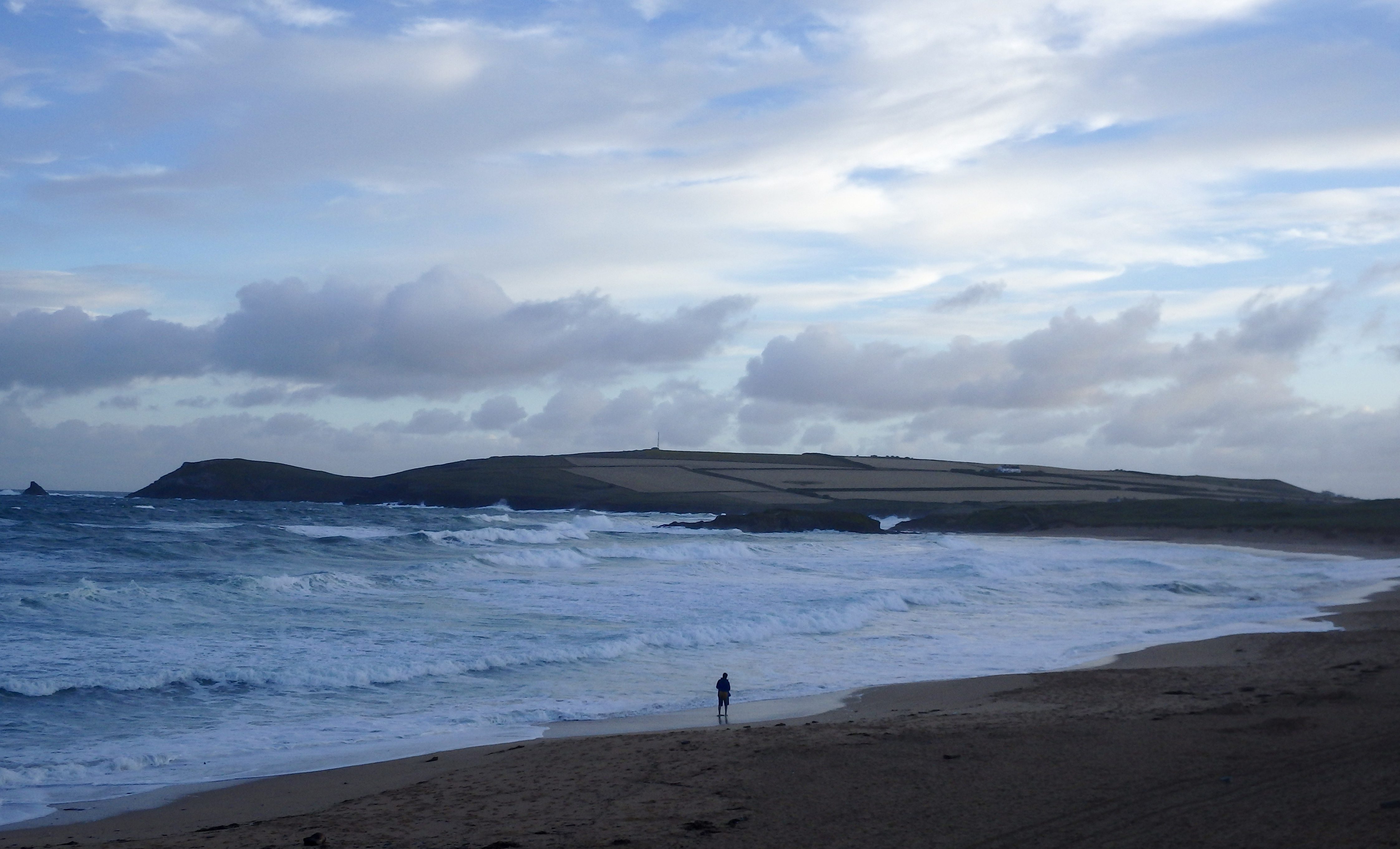
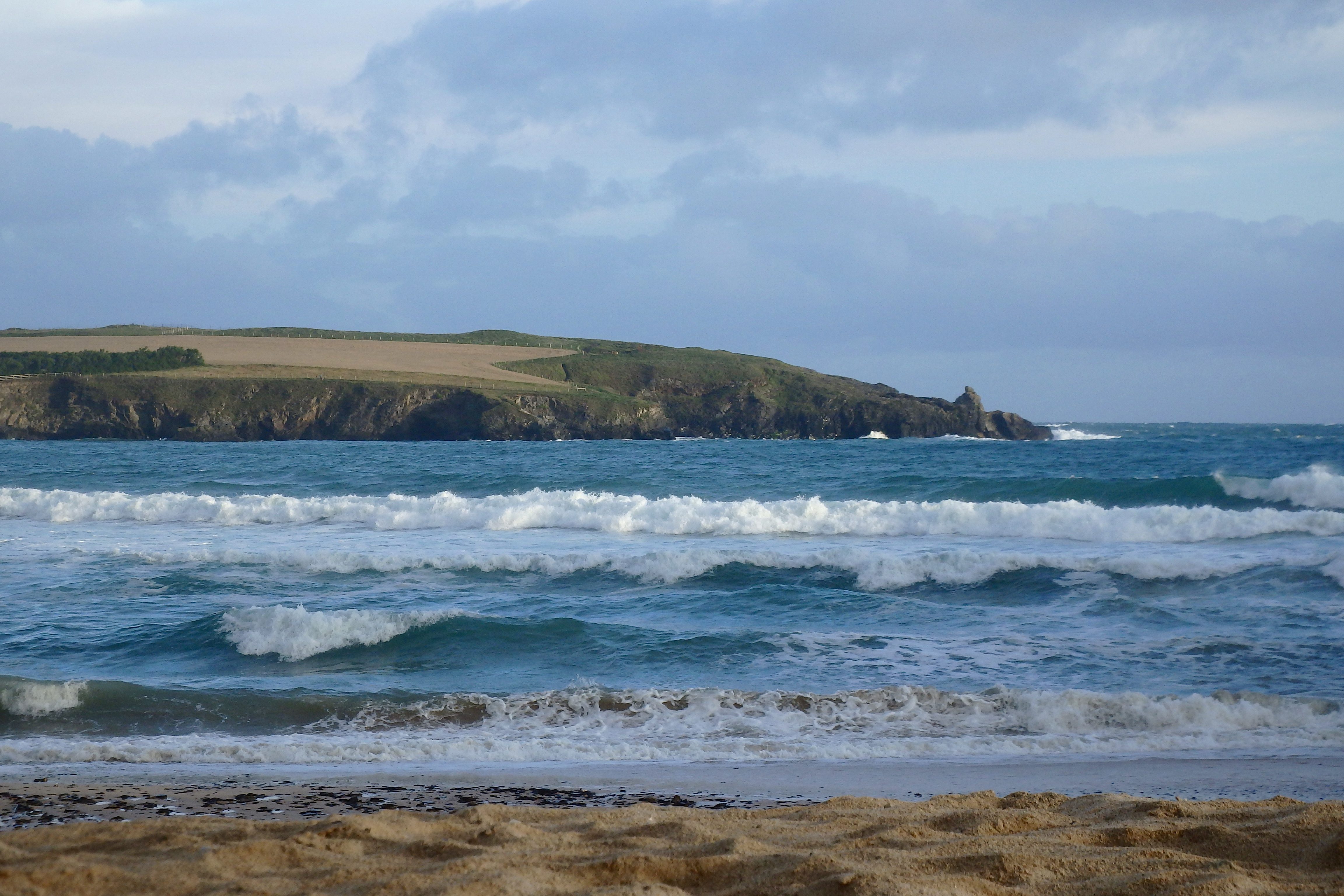
At 6.20 a.m:
Constantine (1*): 4 feet.
As Surfing smoothly gatecrashes the Olympic movement party for 2020, a day like today makes you wonder how far the surfing reality of most hardy north atlantic wave riders is from the cliched and sun-drenched, rich guys’ tropical pastime!
Image is everything!
The wind is blowing out there this morning, those squally gusts dumping large lumps of water around the place, bending the bountiful hedgerows and blowing sand across the exposed bay. It is more Autumn than Summer this early morning but the sky is brightening and those huge cloud banks are reluctantly shuffling off to those far horizons, allowing us to think that it should all come good sooner rather than later!
In the meantime though, the surf is a blown out and messed up four feet or so of bouncy and sloppy junk surf.
A great practice ground for those superfast reflexes that you might one day require as an Olympic competitor but not doing much for most of the rest of the beach users!
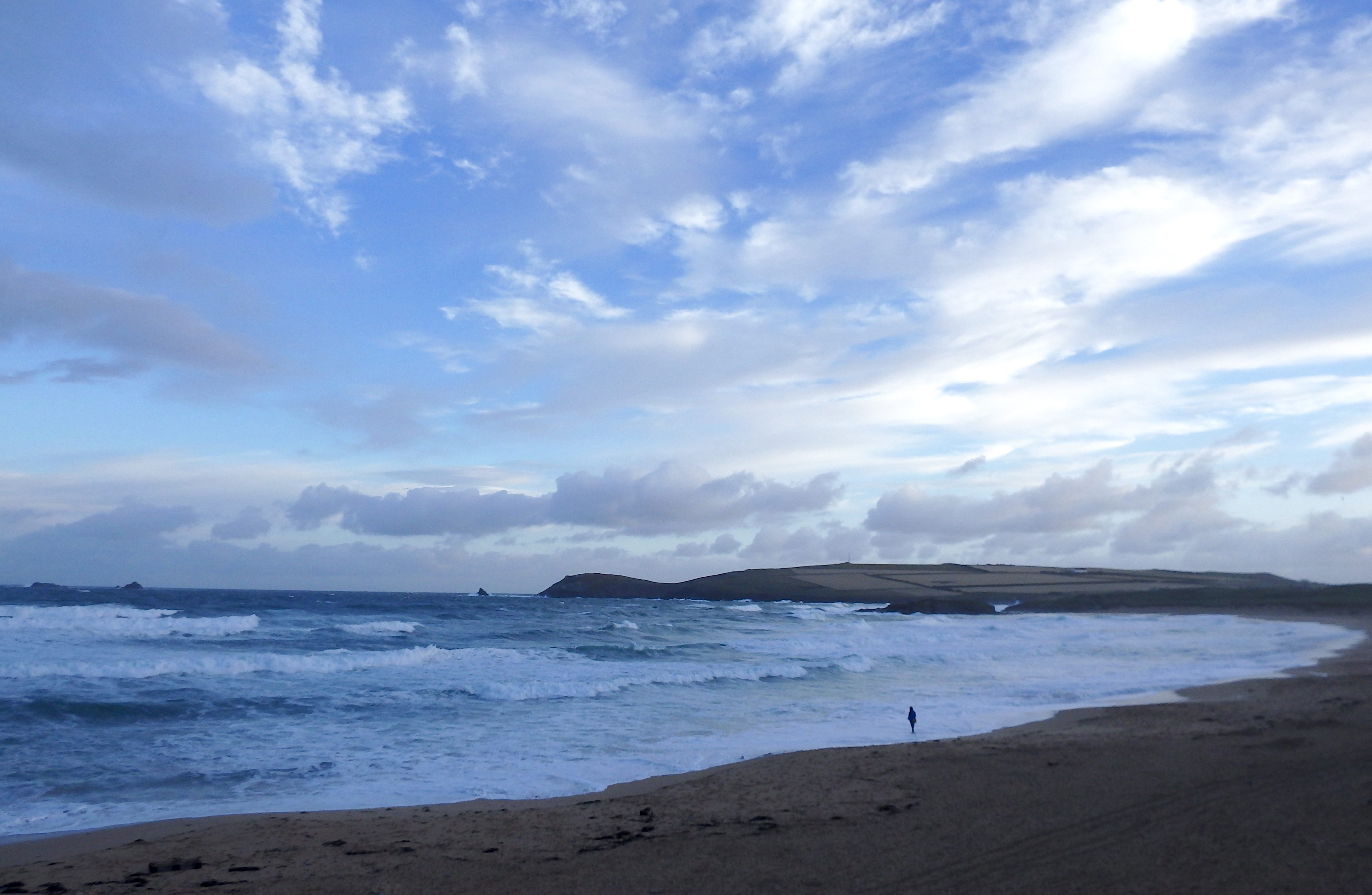
Harlyn (2*): 2 to 3 feet.
The surf isn’t that great around here this morning either!
Three feet or so of slopped out and mushy surf is rebounding off the high tide shorebreak, the backwash at least adding some interest to what would otherwise be a mushy and bumpy, chopped out surf session.
We can only hope that the wind eases in strength and twitches back a degree or two.
But that is unlikely to happen before lunchtime at the soonest!
Today’s Tide Times:
Low Tide: 13:34 (0.9m) High Tide: 19:30 (7.4m)

Surf Forecast for Friday 5th August 2016
Lighter winds are set for today, still north westerly, still onshore, still making a mess of the surf at all of our surf breaks locally.
And it is likely to be smaller too!
So, a couple to hopefully three feet of chopped and slopped junk surf awaits again!
Surf Conditions for the Weekend
As this week blows itself out in an autumnal whirr of strong onshore winds and stabbing downpours, a more pleasant weekend is quietly approaching.
This weekend does promise to be a weekend of two halves, for surfers anyway.
Light onshore, south westerly, winds will chop the surf at the main breaks through Saturday, blowing steadily offshore at the sheltered spots and smoothing the very few tiny waves that manage to get around and into them.
By Sunday we should be enjoying the sight of a new and growing swell, a thick and lumpy, fast building swell pushing onto our coastline with some vigour.
With clearer skies than we have been enjoying for a good few days, this weekend is promising pretty much something of everything for everyone!
Don’t forget the sunblock!
Have a great weekend, wherever you are and whatever you’re doing!
SJ’s Surf Forecast for the SW
Forecast last updated at 07:30 Thursday 4th August 2016
Hi everyone – these updates are currently made at any time of the day as and when I get the time/chance to update – however from September the intention would be for it to be updated every weekday morning by 10am.
[Don’t forget to look at this forecast the day before you go beach for the latest, as things can often change!]
The Rest Of The Week:
‘Autumnal feel to this week with strong winds and plenty of rain.’
Sunrise and sunset – 05:55 and 20:55
Twilight starts and ends – 05:15 and 21:35
Midday – 13:25
Length of day – 15:00
Offshore Sea Temp approx – 16.5C / 62F
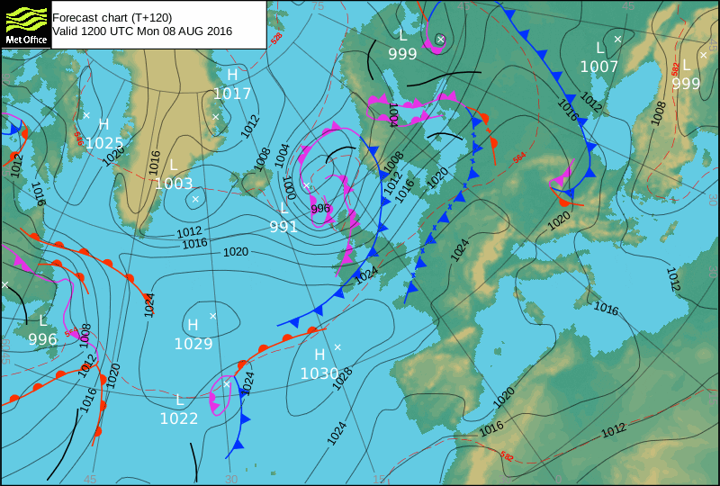
outputmodelrun-040816-0730
Monday 1st:
‘Small onshore waves.’
Swell – (i) Weak WSW-SW
Wind – Light-Medium going Medium SW
Weather – Overcast with heavy heavy rain
North Coast – 3ft (Waisthigh)
South Coast – 1-2ft (Kneehigh)
Tides – 11:09 Low, 17:09 High
Tuesday 2nd:
‘Sheltered spots on the North should be working with a clean wave.’
Swell – (i) Weak going OK W-WSW
Wind – Medium-Strong going Medium SW
Weather – Overcast and rainy start, with the rain stopping by lunchtime
North Coast – 6ft (Headhigh)
South Coast – 2-4ft (Waisthigh)
Tides – 05:28 Low, 11:49 Low, 17:49 High
Wednesday 3rd:
‘Strong wind! Sheltered spots should be holding a good wave on both coasts. Be careful out there.’
Swell – (i) OK W-WSW going W
Wind – Medium going Medium-Strong WSW
Weather – Mixture of cloud and sunshine
North Coast – 6-8ft (Overhead) going 8-10ft (1.5 x Overhead)
South Coast – 3ft (Waisthigh) going 3-4ft (Waist-Chesthigh)
Tides – 06:13 High, 12:31 Low, 18:31 High
Thursday 4th:
‘Nothing on the North with large even dangerous conditions.’
Swell – (i) OK W
Wind – Medium W going WNW
Weather – Mixture of cloud and sunshine, with the odd light shower
North Coast – 6-8ft (Overhead) going 4-5ft (Chest-Shoulderhigh)
South Coast – 3ft (Waisthigh) going 1-3ft (Knee-Waisthigh)
Tides – 06:53 High, 13:10 Low, 19:11 High (Spring tides)
Friday 5th:
‘Poor quality junky/mushy waves.’
Swell – (i) OK W-WNW going Weak W
Wind – Light-Medium W
Weather – Mixture of cloud and sunshine
North Coast – 3-4ft (Waist-Chesthigh) going 2-3ft (Knee-Waisthigh)
South Coast – 1-2t (Kneehigh)
Tides – 07:32 High, 13:50 Low, 19:49 High
Weekend Summary:
‘All change for the weekend, as the track of the low has adjusted itself over the last 24 hours.’
Saturday 6th:
‘It’s now looking like there could well be a ‘window’ in the winds as they turn light SW for Saturday morning. This should mean there’ll be a small cleanish wave despite the cross/onshore winds.’
Swell – (i) Weak W-WSW
Wind – Light going Light-Medium SW
Weather –Mixture of cloud and sunshine
North Coast – 2-3ft (Knee-Waisthigh)
South Coast – 1f
Tides – 08:09 High, 14:26 Low, 20:24 High
Sunday 7th:
‘Although the new long-range swell is still due to hit on Sunday, the winds now look like they’ll be a medium W-WNW which willunfortunately destroy any quality waves for the North. Depending on how the forecast changes, the south coast might be worth a look towards the low tide mid afternoon.’
Swell – (i) Weak W-WSW going Strong W
Wind – Medium W-WNW
Weather – Mixture of cloud and sunshine
North Coast – 2-3ft (Knee-Waisthigh) soon going 8-10ft (1.5 x overhead)
South Coast – 1ft going 3-4ft (Waist-Chesthigh)
Tides – 08:44 High, 15:01 Low, 20:59 High
Early Next Week:
‘Monday should see plenty of good swell – too early to tell what the winds will do yet!’
The scale for measuring conditions:
0-1ft – Unridable/Flat
1-2ft – Kneehigh
3ft – Waisthigh
4-5ft – Chest/Shoulderhigh
6ft – Headhigh
6-8ft = 1-1.5x Overhead
8-10ft = 1.5x Overhead
10-12ft = 2x Overhead
Please Note!
Wave height predictions are based on the larger breaks on both coasts such as Fistral and Croyde for the North, and Praa Sands and Bantham for the South.
Wave height is measured from the front of the wave, and 6ft would usually mean a ‘head-high’ wave.
Try and use some ‘local’ knowledge about what the wave sizes will be elsewhere. For example the Newquay Bay area is generally 1/3 to 3/4 the size of Fistral, increasing the further up the bay you go from Towan to Lusty Glaze, and that it will be clean on a W wind at ‘harbour left’ at Towan at mid-tide’ for example.
Tide times are based on Newquay.
Stay Stoked!
SJ